Cluster (gm-cluster)
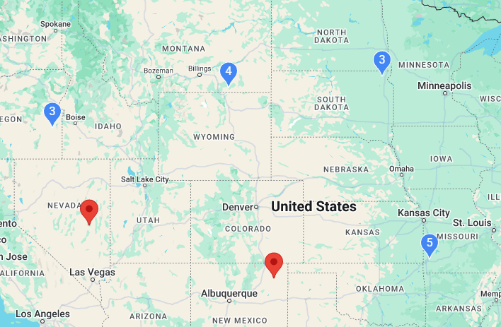
The Cluster is an alternative to the heatmap when showing lots of data efficiently.
Simple Use (demo)
html
<template>
  <div style="height: 500px">
    <gm-map>
      <gm-cluster :items="items" :max-zoom="16" />
    </gm-map>
  </div>
</template>

<script setup lang="ts">
import { gmMap, gmCluster, type GmClusterItem } from 'v3-gmaps';

const items: GmClusterItem[] = [
  { lat: 37, lng: 56 },
  { lat: 15, lng: 108 },
  // ...more items
];
</script>
Props
| Props | Type | Default | Description |
|---|---|---|---|
| items | GmClusterItem[] | - | Items to be clustered on the map. |
| maxZoom | number | 16 | Maximum zoom level at which clusters can be created. |
| pin | GmPin | - | Custom styling for cluster markers. |
Cluster Items
A cluster item has the following properties:
typescript
interface GmClusterItem {
  lat: number;           // Required: latitude coordinate
  lng: number;           // Required: longitude coordinate
  title?: string;        // Optional: tooltip text
  clickable?: boolean;   // Optional: whether the marker is clickable
  draggable?: boolean;   // Optional: whether the marker is draggable
  pin?: GmPin;           // Optional: custom marker appearance
  onClick?: (item: GmClusterItem) => void;  // Optional: click handler
}
Events
| Event | Type | Description |
|---|---|---|
| click | {lat: number, lng: number} | This event is fired when a cluster marker is clicked. |
| mounted | Record<string, any> | This event is fired when clustering process begins with clusters. |
| unmounted | Record<string, any> | This event is fired when clustering process finishes with clusters. |
Notes
- This is a custom component that provides efficient marker clustering for Google Maps.
- The component uses a grid-based clustering algorithm that's optimized for performance with large datasets.
- The
pinproperty allows you to customize the appearance of cluster markers, with the special placeholder{count}in the glyph that will be replaced with the actual count of markers in a cluster.